The first of many I hope!
Please join me for an evening of photos and stories from the trail!
This event includes my Talk AND Slideshow on the CDT and will have plenty of time for Q&A after.
When: Friday November 6th, 2015
Time: 6PM - a light dinner will be served and the presentation will be underway at 6:30.
Place: Church in the Wildwood
5810 West Dahl Road - Deer Park, WA 99006
call 509-844-6143 if you get lost...
Also, I will be doing just my CDT Talk at the Fall Hiker Fest & Trails Celebration in Sandpoint, ID on Nov 7th. This is a free, all day event that includes other speakers and other trails. A fantastic opportunity for learning about other trails! The Idaho Centennial Trail, Pacific Crest Trail, Wonderland Trail, and Mt Blanc Circuit will also be featured. For more information CLICK HERE.
Hope to see y'all there!
Happy Trails,
~beads
Friday, October 30, 2015
Tuesday, September 8, 2015
This world ROCKS!
I know I sort of dropped off the radar for a little while, but that's what happens when a hiker is focused on hiking! Colorado was one of the toughest places I've hiked in a long time. Not only was I battling the mental fatigue that comes with 4 months of challenging trail, but also the almost daily entourage of lightning and hail. Without further ado....
I'm DONE!!!! Not only with the Continental Divide Trail, but this also completes my Triple Crown:
Appalachian Trail: March 2 - Sept 20, 2007 NOBO
Pacific Crest Trail: April 25 - Sept 14, 2013 NOBO
Continental Divide Trail: April 25 - Sept 6, 2015 flip-flop
Over the past 9 years I've had the absolute privilege of spending over a year of that hiking through some of the most spectacular places in our country. Sleeping outside under the stars, breathing the mountain air, and sharing space with the wild trees and creatures that call this world home. I've experienced and learned more than I could have possibly imagined was possible. I've hiked 8,000+ miles, climbed something like 42 Mt Everest's, went through a total of 12 pairs of shoes, and I can't even fathom the number of Snickers I consumed. I've fallen countless times and even walked straight into a tree (not my most graceful moment... it came outta no-where!). I've become friends with the most amazing people from all walks of the earth, many are close as family. I've experience so much love and kindness from complete strangers that my faith in humanity is forever good, never believe the news! I've laughed and cried, fallen in love, and fallen in love all over again. My heart has broken wide open in joy and gratitude... I know the sound of silence and what it feels like to be alive and free.
THANK YOU!!!!! to EVERYONE who has helped me along the way!!!!! I truly could not have done all this without A LOT of love and support from friends and family, and even complete strangers.
Another HUGE THANK YOU!!!! to anyone who has donated to my charities: the Dessin Animal Shelter in 2007, the Colville Valley Animal Sanctuary in 2013, and of course the SPOKANE HUMANE SOCIETY this year. Every cent donated goes straight to the animals! My adventures are entirely funded by myself and a few sponsors. And I am so grateful to the SHS for completely supporting my sabbatical, thank you just isn't enough.
As with my other trails, I will be putting together a Talk & Slide Show to share this wonderful CDT adventure with anyone who wants to listen. It has always been a fantastic evening of stories from the trail, spectacular photos, and overwhelming enthusiasm from everyone! I've done everything from high school auditoriums to a friend's living room... If you would like to help organize a venue in your area please feel free to contact me: talags@gmail.com
So stay tuned!
"You're off to great places, today is your day.
Your MOUNTAIN is waiting, so get on your way!"
~Dr. Seuss
Peace, Love and Happy Trails,
Beads
Tuesday, September 1, 2015
Sprinting to the finish line - pagosa springs
Colorado has been a blur of stunning mountains, great friends, and insane weather nearly every day. As is the theme of my last 3 weeks... I need to get hiking! More to come!
--
Smile Often :-)
Happy trails
Beads
--
Smile Often :-)
Wednesday, August 19, 2015
The Legendary Leadville Hostel
A quick post from the highest incorporated city in the US, Leadville! over 10,000 feet. This weekend is actually the Leadville 100mile Ultramarathon - I will not be partaking but it has been super fun to chat with all the super athletes staying at the hostel. I can't imagine running 100 miles straight and they can't imagine walking a marathon nearly every day while carrying a pack for 4-5 months. Met Pappy - a Triple Crowner from 2002!!! he started his adventuring at the age of 65 and is still going strong.
HUGE THANK YOU to Carol and Gary who put up with me in Grand Lake!
The weather has calmed a bit for now but it is easy to forget how crazy and miserable it can be to hike up high and be completely exposed while mother nature rages. I'm moving steadily onward but have to admit I'm very much looking forward to laying on a couch for a week straight when I get back! Getting closer!!!
Happy Trails!
~beads

Saturday, August 15, 2015
Never Summer Wilderness
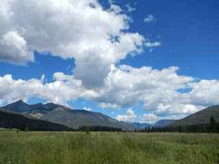
What a name for a place! Never Summer was certainly a place that had fall in the air... in mid august. The mountain meadows are starting to turn golden yellow, the high alpine shrubs are turning bright red... it is looking more like fall at 11,000 and 12,000 feet than I'd like to admit. It certainly keeps me hiking to try and beat the snow!
Since last time I've completed southbound from the Great Basin of Wyoming into Colorado to Rabbit Ears Pass and spent an absolutely amazing time with Steamboat Star (miss Jayne). She literally picked me up at the Post Office and knew exactly what a girl from the trail needed to relax and recoup. Thank you girl!!!!
Then it was off through the Never Summer Wilderness and into Rocky Mountain National Park. The trail actually goes through Grand Lake at the southern end of the park and there is an impressive Hostel called Shadowcliff that I HIGHLY recommend to anyone visiting. WOW!
I still need to get used to Colorado's classic afternoon thunderstorms but so far I've had hail the size of peanut M&Ms and lightning so close there's no gap between flash and crack. The vast majority of the trail is up at 11 and 12,000 feet, which makes navigation particularly challenging in the afternoons.
This state brings a whole new perspective to the mantra of the CDT: Embrace the Brutality!!!
Welcome to Colorado!!!
Trying new things... click on the link below to (hopefully) see a little video of me in the Winds!
http://youtu.be/P0VYWMcQFpc
Happy Trails!
~beads


Friday, August 7, 2015
Home Stretch
This year, many of the thru-hikers have had to patch together their hike because of challenging weather patterns. Some hearty souls did hike through the snow, some continued on a lower route, and some avoided it all together by either waiting for going somewhere else on the trail to hike while the snow sorted itself out. My 2 previous thru-hikes were straight through, no flipping or flopping like this year. The decision was difficult was SO worth it in the end. I now sit in Saratoga WY and plan to head to Battle Pass tomorrow to start my last chunk south into CO and back down to Ghost Ranch.
I just went through the Wind River Range: truly the best kept secret in Wyoming. Massive crags of solid granite towered around me with endless high alpine lakes and glacial valleys. Rivers glowed turquoise from glacial runoff. The vegetation was thick and rich down below treeline with mosses and old man's beard clinging to every surface. To get a better look check out my new video (getting posted soon) by clicking on the Donate Now button to your right.
Thanks for reading =-)
Happy trails!!!
~beads


Saturday, August 1, 2015
Wyoming - Forever West

The last few days in Montana and Idaho proved to be one last hurrah by mother nature to make sure we don't forget our time there. A 32 mile day to get up and over Mt Taylor only to sleep on a tiny saddle with wind howling and driving rain all night. The next day was cold and wet, Kramers and I bushwhacked through miles of thick willows as I was wearing nearly everything I had with me. We did, however, see 3 beautiful moose who were also out enjoying the brisk moist weather. What a treat!
Thru-hikers love state lines. We tend to mentally break down the monumental task of a thru hike into smaller pieces and state lines are a great goal. I had been hiking in Montana since June 10th and it was absolutely awesome, but getting to Wyoming was a great feeling of accomplishment. The MT/WY line is in western Yellowstone National Park and we literally get to walk in the back door of the most visited national park in the country. The backcountry trails are used very little but when we get closer to a parking lot we can hear the traffic, then the trail suddenly gets 6 feet wide, then we can literally smell the bug spray of the day hikers before we see them. Some tourists are very happy to say HI and GOOD MORNING but there are many who are not interested in making eye contact with scruffy backpackers. Kramers, Handstand, MachineGun, and I arrived on the boardwalk smack in the middle of Biscuit Basin and spent 2 hours strolling 2 miles toward Old Faithful, weaving around sapphire blue hot springs and sputtering geisers. It was incredible. I had never visited Yellowstone before so it was a perfect opportunity to relax and play tourist for a little while. Watch Old Faithful erupt. Cruise through the visitor center and read all the exhibits. See the ranger programs. And of course explore the super historic Old Faithful Inn. For a moment I didn't feel like a hiker, sitting in the Old Faithful Inn by the fireplace with a Brandy Alexander while a fiddle player serenaded us from the 2nd floor balcony overlooking the massive central atrium. Dusk came far too quickly and we had to scurry off to our campsite for the night.
After Old Faithful Village we continued through the park for another 50-ish miles before hiking into the Teton Wilderness. We got hit with yet another weather system that was even colder than the last. Isn't it July?!?! There was an entire day that didn't make it past 46 degrees and at night went into the 20s... again, I was wearing everything I had to stay warm.
The sun came out and warmed our faces, dried out tents, and we walked on into the Teton Wilderness. A beautiful, remote area that was clearly heavily used by horse packers. Sometimes hikers get frustrated with having to walk on endless uneven dried mud but in reality, we love horse country. The trails are well maintained and easy to follow. We even get labeled intersections!!! What a treat!!
A favorite little place was called Two Ocean Pass and the "Parting of the Waters". There is a creek that literally hits a rock and splits into Atlantic Creek and Pacific Creek. Yup, we threw in a stick to see which way it would go =-)
The next section from Togwotee Pass down into the Wind River Range will mark 2000 miles for me. It's exciting. Then I hitchhike around the Great Basin (I hiked that back in early June) and head into CO. It's hard to believe I "only" have 800 miles left...
Thanks for reading =-)
Happy Trails!
~beads
--
Smile Often :-)
Thursday, July 23, 2015
last town stop in montana
After a stunning 800 miles on montana it is finally almost time to hike through Yellowstone National Park!
--
Smile Often :-)
Feeling good out of Leadore, the weather has been a little finiky and by the time i made it 100 miles to route 15 into Lima i was very much ready for a rest day. Other than almost getting sprayed by a skunk it has been the same awesome trail.
Once i get to Wyoming there may not be many opportunities to update my blog...
Happy trails!
Beads
--
Smile Often :-)
Wednesday, July 15, 2015
Bannock Pass - Leadore, ID
Traveling through the Bitterroot Mountains along the Idaho-Montana border has been absolutely incredible. High mountain meadows, open tree groves, and wildflowers still holding on. This section of the CDT as we head down to Wyoming has a reputation for what hikers call PUDDING. That is: Pointless Ups and Downs. Well built trail is something that takes countless volunteer hours to construct and the better a trail is built the less a hiker notices. In this area the CDT often follows old 4wd roads and for some reason this seems to imply that we go straight up and straight down every little pointy bit along the Great Divide. Definitely not easy on the feet/knees/legs of any hiker! I also find myself pausing to ponder the thought of HOW exactly someone might actually drive up and down these paths... they are so steep I can't imagine any outcome other than flipping right over!!
Other than the extreme fire danger that surrounds us, the weather has be quite agreeable. I have not been directly effected by any wildfires despite frequent lightning strikes in the area. After the insane heat wave from 2 weeks ago, the temperatures have settled down. Recently, however, we have been dealing with daily thunderstorms and rain. Nothing too disheartening but it sure does keep you on your toes. Luckily there has been at least a small window every day to dry out my tent, other than that I basically just keep hiking in the rain. It has its own beauty I think, its own challenges as well.
Thanks for reading!!!
Happy Trails,
~beads


Thursday, July 9, 2015
half full
Greetings from sula! A small store with rockin breakfast, hot showers, good beer selection, and mini golf. What more could a girl want!?! The recent trail took us through the Anaconda-Pintler Wilderness and some of the most gorgeous views yet. After the sweltering heat and road walking through Anaconda, I definitly needed some good high alpine meadows and exciting brisk thunderstorms on top of 9000 foot passes. We got it.
--
Smile Often :-)
Sometime in the recent past i crossed my personal half way point!!! It has been a more challenging trail than the AT and the PCT for many reasons. Difficult weather decisions and chronic foot problems are hopefully a thing of the past. I have never had foot pain like this before and walking 25 to 30 miles a day can really wear on you mentally. There were definitly days i wanted to go home. I'd try not to complain but I'm sure they saw it on my face and my ginger steps down hill. Every time the pain was almost too much Papi or Kramers would offer a foot massage at the end of the day. I am one lucky girl. The entire time there was no swelling, which means no broken bones, just soft tissue... for now my feet are much better. I really hope they stay this way!
I think every long distance hiker has mixed feelings about halfway. It is a fantastic accomplishment that anyone would be very proud of. 1300 miles. An amazing life of sleeping outside and walking through some of the most spectacular wild and remote places that our awesome country has to offer. There is a small voice in my head that wonders if I'll make it all the way. Wonders how hard it will be. Wonders if i have the mental strength to get up and walk a marathon every day for another 2.5 months. Then i remember why I'm out here. The journey.
Thank you!!! To all who have made it possible for me to be out here! I truely hope to repay the favor one day. All my animals are surely having a grand time without me :-) wishing you all much peace and love this summer.
Happy Trails!
Beads
--
Smile Often :-)
Sunday, July 5, 2015
Anaconda, MT
Greetings from beautiful Anaconda! I just spent July 4th watching the town parade and enjoying fireworks with a few other hikers and some fabulous locals. I am roughly half way through Montana and have a lot more hiking to do!
--
Smile Often :-)
Happy trails!
Beads
--
Smile Often :-)
Monday, June 29, 2015
My New Favorite Things
Currently sitting in the Missoula Public Library it seems like the trail is a world away. Glacier National Park was so incredible I pinched myself every day. After leaving East Glacier Park I have been traveling with Papi Chulo and Kramers, the company has been really nice. It's so much fun to be journeying with people who share my enthusiasm for the fact that every day is simple the best day of our lives.
The Lewis and Clark National Forest blended into the Bob Marshal Wilderness and we we found ourselves in the most remote stretch of the trail. This corridor of mountains are wild and free. Bear and wolf signs EVERYWHERE! It was so great. And the WILDFLOWERS are absolutely STUNNING!!!! Parts of the forest had been burned by fire in recent years and we entertained ourselves with games of "Tree Tennis"... basically taking turns pushing trees over =-) these skeletons of wood and charcoal can literally fall at any moment (often without wind) and are quite dangerous to anyone passing through the area.... just doing our part to make this mountains safer! In the BOB we came across a few Forest Rangers clearing trail and pack mule strings carting loads of supplies into maintenance camps. Everyone is basically trying to get as much trail clearing done as they can before the fire season sets in and they are called away to help with fires. What a life! We also got the pleasure of hiking right under the Chinese Wall, a massive rock cliff that stretches for miles and is the main attraction for anyone visiting the BOB.
After resupplying at the Benchmark Ranch (Kyle sent me a resupply box with food and maps) we continued south. Without that resupply option I would have had to carry nearly 10 days worth of food, THANK YOU BENCHMARK!!!! After traveling along many fabulous trout rivers and having visions of fishing we climbed to the ridge and for the first time this trip we actually hiked along the Great Continental Divide. It was so special to be sleeping on top of a ridge at 8000 feet watching the sunset dancing on the thunderheads in the distance. Then to wake up to the sunrise to the east. This just might be the best day of my life.
As the days passed we notice the mid-day heat slowly climbing past 80. With a breeze on the ridge it was manageable but we get word that a heat wave is coming. 100 degrees in Helena. The day before we hit route 12 to Helena we were actually hiking by 5am to take advantage of the cool morning. By 1 we stopped for a Ciesta because the thermometer read 86, and we were at 8000 feet. We took naps and cooked dinner. By 5 the heat seemed to be cooling off. When we left 8000 feet it was a lovely 72 degrees, within and hour we were down to 7000 feet and it was 83 degrees. That's not bad when you're sitting in the shade with an iced tea but when backpacking with 15+ miles between water sources you really do have to pay attention. The three of us are taking a couple days to relax and let the heat wave pass. The next few sections are a little lower in elevation and we are very much hoping the weather settles down a bit. With fire season on the horizon we are glad to be moving south!
Happy Trails!!!
~beads

 |
| Chinese Wall in Bob Marshall Wilderness |

Tuesday, June 16, 2015
Glacier National Park
After many hours of driving, sitting in the Backcountry Office figuring out our permits, picking up maps at the Post Office, making sure I had enough food, checking snow conditions over the many passes ahead, and generally just getting super anxious.... myself, Bearclaw, Dirtmonger, and Papi Chulo were at the Chief Mountain Border crossing last thursday at 8 pm with 6 miles ahead of us. Lucky for us it gets dark at ten. As we got closer to our destination we all gawked at the mountains ahead, even got caught in a massive hail storm and was thankful we were in a car.
As we hiked up glacial valleys and climbed over multiple high mountain passes we all just kept looking around in disbelief... this was clearly the best days of our lives!!! Our legs pumping, lungs heaving, and hiker hunger returns: this is what it feals like to be a thru-hiker. Most of the passes, Papi Chulo and I seemed to be the first people over the pass this spring. There was lots of animal tracks (Grizzley, Black Bear, Wolf, Coyote) but no shoe marks. There was definitly a few bits of snow left still melting but we strolled over them singing our own song "Not Post Holing, la dee dah!" The whole time we felt like kids in a candy store. Surrounded by massive cliffs down to tiny alpine flowers: truely a magical place.
This park was created back in 1910 primarily by the Great Northern Railroad as a "See America First" Campain. In no time they built an entire network of Lodges and Chalets throughout the park that were a day's horseback ride apart. Visitors would get off the train in East Glacier and then explore the park by horseback and boat. By 1925 there were 1,000 horses carrying 10,000 visitors annually. Many of these mountain lodges are still here and a huge part of the history. We had the pleasure of walking by Many Glacier Lodge, Two Medicine Chalet, and later today I plan to curl up in front of the fire at the East Glacier Lodge. What a treat!
The trail goes through East Glacier Park (town) and we are resting up for our nest section, the BOB! The Bob Marshal Wilderness is tauted as some of the most wild mountain country we go through. I didnt have the pleasure of seeing a Grizzley in Glacier but my chances are supposedly much higher in the Bob, I'm stoked!!! It is also out longest section without roads or cell service. We are lucky that there is a Ranch that lets hikers send resupply packages so that we dont actually have to carry 200 miles worth of food all at once.
My plan from here is to try and keep it simple, hike south. This will have me finishing the trail in northern NM in the San Juan Mtns. Not quite what I had planned but it has been a great exercise in adapting to what Mother Nature throws at you. Despite major set-backs, I'm still confident that I have enough time to finish the trail this summer. For now, I'm just enjoying the moment.
Happy Trails!
~beads


 |
| Wonderer (from Japan), me, and Papi Chulo enjoying a fire at Two Medicine Lodge |
Tuesday, June 9, 2015
CDT insanity - Southbound from the Border

A lot has happened since my last entry but the take home message is: I'm heading to Glacier National Park to proceed with my hike southbound. The snow in Colorado is still unmanageable and it was an extremely low snow year up in MT so myself and 11 other hikers are taking the plunge and going to the Canadian Border to walk toward the sun. I'm absolutely thrilled to finally have a GOOD plan with regards to dealing with this snow. The fact is, Colorado is still at 150% to 200% snowpack, the avalanche danger is still extreme, and stream crossings are dangerous. This hike is not worth risking my life to that extent and I'm not willing to road walk through some of the most stunning parts of CO if I can avoid it. I want to walk through the San Juan Mtns in all their awesome glory, and with this plan that will be my finale.
Ive hiked approximately 800 miles so far. In the grand scheme of things I have a lot more work to do but it still feels good to have that many miles behind me. This time tomorrow I should be up near Glacier National Park gawking at the massive glacial valleys and ready to move my feet.
And of course while I have the simple task of walking, Kyle my resupply person is probably having an ulcer because of me. All the nicely wrapped boxes must be torn apart and re-organized to accommodate the fact that I'm now traveling south, not north. For anyone who has had this responsibility, you know how nerve-wracking it can be!
So what have I been up to for the past week or 2? I hiked north from Rawlins WY, through South Pass City (an AWESOME state historical park that the trail goes right through), and onward to Pinedale. I stayed on the trail as far north into the winds as I could but did end up having to bail down to roads for the last bit into Pinedale. At the time that I rolled into town I had no idea what I was going to do. I could continue north where there is much less to no snow but I would have been totally alone, all other hiker were still grappling with the snow in CO. Or I could have stuck with my original idea of going back to CO and trying to get through the snow but the more reports I got back from hikers and the more snowpack data I combed through this just didn't seem like a reasonable option, despite the lure of awesome company. Then this past Saturday, FINALLY a group of hikers decided to drive up to Glacier and southbound from the border. Did they have room for one more? YES!!!!!!! So for a few days I've been resting in a very familiar place, Jackson Hole WY. Good friends, good food, dancing, singing, and good vibes. Boy it's nice to be surrounded by such a positive energy!!
Happy Trails!
~beads
--
Smile Often :-)
--
Smile Often :-)
Friday, May 29, 2015
Whirlwind
Last sunday I was reviewing my options: Keep hiking into the snow and see how bad it is for myself, or make plans to head up to Wyoming's Great Basin to hike some miles while this snow business sorts itself out a bit. Reports of the San Juans included things like "150% snow pack" and "extreme avalanche danger"... I was very much leaning toward the Wyoming option but then the new decision was: how do I make it up to Wyoming and back? Public transportation is just awful in this country for anyone not heading from giant city to giant city. I called a good friend from the PCT in 2013, Happy Feet/Chad, who lives just south of Denver to see if he had any ideas. Within 10 minutes he offered to drive 5 hours to come pick me up on his day off. WOW! By 2 AM i was in Castle Rock CO. The next day I made it to REI to get new tips for my poles, they were down to the nubs! It's always great catching up with awesome hiking friends, we hadn't seen each other in almost 2 years and we didn't skip a beat. THANK YOU CHAD!!!!!
Dropping me off in Cheyenne, WY I had my first hitch in 5 minutes! Peter took me over 100 miles toward my goal of Encampment, WY and we talked the whole time, it was a beautiful drive. My second hitch was from 2 gentlemen from my home state of PA out on vacation and before I knew it I was in the tiny little town on Encampment. After a delicious lunch @ the Bear Trap and confirming with the Post Office that my maps didnt arrive yet (a girl can hope!) it was time to decide what to do with and extra day waiting for maps to arrive...
The next town north is Saratoga and the best part about this little town is the public hot springs! And they're free!! So, out goes my thumb one last time that day in pursuit of ultimate relaxation. Within 20 minutes a local fly fishing guide picks me up and by nightfall I'm checked into the Sage & Sand Motel and was partaking of a local play "Cheaper by the Dozen" before heading to the hot springs 3 blocks away. Dusty at the Motel was probably the coolest motel manager I've ever met and EVERYONE should stay there!
What does a hiker do when waiting for maps? Hot springs and Fly Fishing of course!!!! Remember that fishing guide that picked me up? Steven Heinitz of North Platte Trouters (www.nptrouters.com) is an absolute ANGEL and took me on a float trip down the North Platte River in search of some stunning scenery, awesome wildlife, and trout of course! I hadn't held a fly rod in my hand for 8 years, and had also never fished from a boat, but before I knew it I was totally lost in the experience around me and had an absolutely incredible time!!!! Thank you SO MUCH Steven!!!!! (and Buoy).
I loved the irony that I was fishing on the water that is the snowmelt from the mountains that I was avoiding... Just taking advantage of the situation ;-)
With all of that adventure it was time to hike. I'm in Rawlins today and plan to continue on to South Pass City, then Pinedale, before heading back south to Ghost Ranch where I left the trail.
Happy Trails!
~beads
 |
| feeling good after a big snowy climb up Los Pinos to Los Pedros Peaks @ 10,600 feet |
 |
| Indian Paintbrush in Chama River Valley |
Sunday, May 24, 2015
Ghost Ranch
A stunning setting that inspired Georgia O'Keefe's historic work...
Straight out of Cuba we had an entire day of snow, slush, post-holing, freezing fords, and numb/wet feet. It's was beautiful up at 10,600 feet but I was still glad to be back down at 8,000 feet and out of the snow. Today? rain. This has been the coldest, wettest spring that any of the locals can remember.
The snow is literally falling up in the San Juan Mtns as I write this. Decisions, decisions.
All part of the fun!!!
Happy Trails!
~beads
Thursday, May 21, 2015
Mach 7 Drizzle and Beautiful Mesas
Here in Cuba, NM enjoying some good mexican food and the fantastic hospitality of the Del Prado Motel and owner Mrs.Yang.


Crossing the 500 mile mark it is amazing to think back at the various environments and weather conditions that have been thrown at us so far. Definitely more than any other trail experience I've had thus far. We've had everything from barren dusty desert to high alpine pinon forest to wild river fords to lava and volcanic rock to mesa features over 2000 feet tall. The weather has ranged from mid 80s down to 22 degrees and I believe we have had pretty much every kind of precipitation at least for a short time. Snow, sleet, hail, rain, and mach 7 drizzle. We went to sleep 3 nights ago literally in the middle of a thunderstorm and had more than a few lightning strikes within a couple miles of us. It was getting dark fast and with a 2000 foot descent in front of us we decided to camp at the top of the mesa despite the storm; there were lots of good trees around so it definitely could have been more precarious....
With the multiple storms rolling through there has been a lot of concern among hikers regarding the snow coming up. Low seasonal snow packs have made us hopeful but now that there is fresh snow on the ground it is turning out to not be quite the walk in the park we were all secretly hoping for. From here I hike up to Ghost Ranch and then Chama is my last chance to get snow gear before heading north into CO. Even between here and Chama we will likely encounter a bit of snow. There are many factors to consider. I am quite comfortable traveling and camping on snow, I probably have more alpine experience than the average hiker, but the real issue is navigation and speed. I have been covering 25 to 30 miles a day and snow would greatly decrease that forward progress. Some hikers are slowing down to give the snow more time to melt, some are talking of trying to push through into the San Juan Mountains anyway, and a few are thinking of what we call a "Flip-Flop". I may potentially travel up to Wyoming to do the Great Basin and give CO a few more weeks to melt out, then do CO southbound. Once I make it back down to where I got off the trail I'll then have to travel back up to WY and continue northward to Canada. It's just an idea. It will be a week or 2 before I make the decision but for now I will simply continue north. Tomorrow will be my first day over 10,000 feet and there is a good chance the thunderstorms rolling through tonight will drop some snow.
The trail through mesa country has been absolutely incredible. Maintained by the Back-Country Horsemen of NE New Mexico they have clearly put a lot of time and energy into building the best trail we've seen yet. Very well marked with rock cairns and posts and really taking advantage of the natural awesomeness around us. At the top of the mesas the trail would travel right along the edge, we even cowboy camped on the edge of the mesa one night.
Fun trail term: Cowboy Camping is something many hikers will do in the desert. With no humidity there is no dew. And more importantly there are no bugs to bother you as you sleep. It's fast and efficient, and more importantly you get to sleep under the stars in the fresh desert air.
Time's up at the library computer....
Happy Trails!!
~beads


Friday, May 15, 2015
The Land of Enchantment - New Mexico
Greetings from Grants!!!!
Boy has New Mexico truly been a land of enchantment. The flowers are gorgeous, the weather hasn't been nearly as unpleasant as it could be, and we are certainly not just walking through a boring desert. Beautiful sandstone cliffs and even lava fields from Mt. Taylor (to the north) have filled the days recently. Many of the places we travel through know the hikers are heading north and like to support us. I've even had a police officer stop to ask "what are all the hikers doing in town?" and of course I got the chance to tell him all about the Continental Divide Trail and how we are all crazy enough to try and walk to Canada in 5 months. It's so much fun to see their faces when they hear about the trail for the first time, and then take one look at me and ask... "so how long have YOU been out?" It's a fun life walking from place to place making my way northward. I just looked at a map of New Mexico and had a WOW moment when I realized how far I had walked already. I still have a lot to go but it sure is amazing to realize how far a person can walk just by doing a little bit every day.
So far there have been a few small climbs but overall the "trail" has been a gentle grade. Burrows Peak and Mangas Peak and a few 1-2000 foot climbs have been it, a nice introduction while my feet get stronger. Just to the north of Grants is Mt. Taylor, some hikers choose to do a short side trip to climb the mountain (I'm not sure yet if I will do this) but between here and Cuba, NM the mountains really start to stretch upward and Lion Heart and I will have a bit of work cut out for us. I do like it when the trails go upward, the views are always worth the effort!
There have been a few hikers so far that have had some serious stress injuries... a reminder to take care of ourselves and rest when we can. It is amazing that we can literally walk from dawn until dusk with a few short breaks and be able to get up and do it again tomorrow. Even when our bodies are stiff and sore at the end of the day we can still keep walking once we loosen up and keep going for just a few more miles. Swollen knees, tibia fracture, metatarsal fractures, plantar fasciitis, Achilles tendonitis.
Fun trail culture factoid: A Trail Angel is anyone who helps hikers. Sometimes this generosity is a surprise and sometimes the hikers know of an Angel in town ahead of time. Trail Angels do things like offer water by a hot road, offer rides, set up surprise food stations, even just offer a cold beverage to a hiker as they drive by! It is absolutely amazing how many genuine loving experiences hikers have from complete strangers. Apple is an Angel I met on the Appalachian Trail in 2007 and guess who I met in Lordsburg helping hikers!?!! It was truly a surprise to see a familiar face out in the middle of the desert cooking hotdogs and handing me a cold Gatorade. Nita in Pie Town is an absolute Angel for offering her Toaster House Hostel to hikers as a great safe place to relax and recoup. Sheridan is a local rancher in Pie Town who happens to travel along the road that hikers use to walk into town, he keeps a small cooler of drinks in his truck and boy is it a nice treat in the middle of the day on a hot road walk!!! Even heading north of Pie Town we met Ann and John Thomas who have a sign up at their gate inviting hikers and bikers in to get water from their well. In the midst of countless "No Trespassing" signs it is a welcome site to see a friendly driveway and of course we got much more than just water. Ann and John are a very sweet older couple that very much enjoyed telling us their stories and adventures and clearly loved just taking care of the hikers coming through and making sure no-one needed anything. Plus it's all part of the hiking experience to meet the locals and learn a bit about what it's like to live here =-) THANK YOU!!!!!!!!
Happy Trails!
~beads
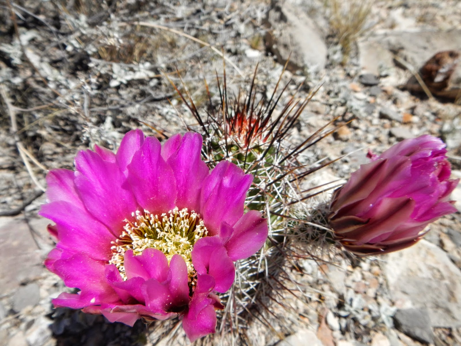
 |
| Prickly Pear Cactus Flower |
 |
| Going off trail a bit (oops) allowed me to find this weather transceiver from NOAA! (on top of my pack). They send these things up in weather balloons to learn about our atmosphere and then they come back down to earth when they're done. By sending the device back to them they may be able to use it again =-) Glad to help NOAA!!!! |
 |
| double rainbow on the Gila River |
 |
| Amazing Sandstone Cliffs at the El Malpais National Conservation Area just south of Grants |
Monday, May 11, 2015
Gila River and Snow in the desert
It's official, it snows in NM in May! The past few mornings have been below freezing and sure enough it snowed on us two days ago. What an adventure! We did our best to keep our shoes from freezing over night and i was SO thankful for my big down jacket. Being on or near the divide means we have been hiking between 7 and 9000 feet in elevation. The temps have been quite mild so far and the ecology has included lots of Alligator junipers and Douglas pine. Lots of elk north if the Gila river, even some Pronghorn antelope already.
The Gila Wilderness was an awesome and challenging segment. The actual Divide is up in the Black Range but this river route is a commonly accepted alternate. A true gem of NM it also gives hikers a chance to check out the Gila Cliff Dwellings National Monument. The Gila river is wild and remote. Encased by towering canyons the "trail" has no choice but to cross the river each time the water zigs and zags across the narrow canyon floor. I'm sure someone has counted how many times we ford the river... Let's just say it was well over a hundred in about 45 miles. A flood washed out most of the trail and keep in mind our days of wading thru a very cold river started at 645am and went until 8 pm to take advantage of as much light as possible. Putting on those shoes in the morning was quite a challenge but it was long days of ankle crushing cobbles, sand, and very wet feet. It was a good thing the canyon was so spectacular!
Lion Heart and I strolled into Pie Town late yesterday to find a fabulous hostel called the Toaster House and excellent pie. With aching feet and sore legs we are resting a bit today before moving on to Grants next. With 340 miles behind us we still have quite a bit to go but after 16 days on the trail we're really starting to settle into our trail routine and our bodies are getting stronger. It feels good to be out here exploring New Mexico on our own 2 feet. For more details of our days I encourage you to check Lion Heart's blog that I previously posted. Our journeys have differed a little but for the most part it is not dissimilar to my personal experience... Enjoy!
Happy Trails!
~beads
Happy Trails!
~beads
Tuesday, May 5, 2015
Gila wilderness
Lion heart and I are still going strong. I have had some blog issues and won't be able to fix it until I get to a real computer so apologies for the short posts and lack of updates.
On Saturday we relaxed in Silver City NM and enjoyed a cycling race that was going on in town. Good times with great company!
Sunday we got an early start heading into the Gila Wilderness. WOW! dry desert has made way to steep canyons and countless river crossings along the head waters of the Gila Diver. Truly an oasis. Being so remote means little connection to the outside world. In about 6 to 7 days we should be rolling into Pie Town and hopefully give you all a better glimpse of this world down here in NM.
 Happy Trails!
Beads
Happy Trails!
Beads

Wednesday, April 29, 2015
Welcome to the Desert
Saturday morning 10 hikers gathered in the Econo Lodge Lobby in quiet, focused, contemplation, much like the energy right before a race. Lion Heart, Coincidence, Hot Tub, K2, Ridge Runner, 2 weeks and 3 days, Lumber, Scat Man, Addy, and Myself. Mentally going over everything in your head making sure nothing is forgotten, hoping your mentally and physically prepared, and praying everything goes well. Even with perfect preparation things can still not go as planned and all I hope for is that I have the knowledge and ability to approach those situations and be able to overcome them. As a single female hiker it is rather empowering.
The ride to the border took 3.5 hours and the second half was entirely a 4WD experience that no rental car could possibly handle, we were all immensely thankful for the convenience of the shuttle, THANK YOU CDTC!!!! A quick group photo at the monument, a few individual poses, last minute water check, and we're off!!!! A comfortable 65 degrees with gentle breeze at our backs, beautiful.
 On day 2, Lion Heart and I woke to 58 degrees and dark clouds on the horizon... within an hour we were hiking thru rain and sleet blowing straight at us. Being the desert there's no place to hide so we keep hiking to stay warm, it was incredible. 2 hours later the weather finally cleared a bit and we were able to dry out our gear a little before the next wave of thunderstorms came, this time the hail hurt a bit! Boy was I glad I brought all of my rain gear! Welcome to the Desert!!! We later found out this storm system brought a lot of snow to the mountains up north, very glad to be down here in the desert warming up.
The next 2 days of hiking was a lot of aching legs and sore feet. While the sun was back in fine form the heat really wasn't that bad with a high of mid 70's. Very few places to get out of the sun means I have to be hyper-vigilant about keeping covered as much as possible. Despite best efforts I still have a touch of sun on my face and calves, nothing unexpected considering I came from the great north!
On day 2, Lion Heart and I woke to 58 degrees and dark clouds on the horizon... within an hour we were hiking thru rain and sleet blowing straight at us. Being the desert there's no place to hide so we keep hiking to stay warm, it was incredible. 2 hours later the weather finally cleared a bit and we were able to dry out our gear a little before the next wave of thunderstorms came, this time the hail hurt a bit! Boy was I glad I brought all of my rain gear! Welcome to the Desert!!! We later found out this storm system brought a lot of snow to the mountains up north, very glad to be down here in the desert warming up.
The next 2 days of hiking was a lot of aching legs and sore feet. While the sun was back in fine form the heat really wasn't that bad with a high of mid 70's. Very few places to get out of the sun means I have to be hyper-vigilant about keeping covered as much as possible. Despite best efforts I still have a touch of sun on my face and calves, nothing unexpected considering I came from the great north!
 The trail so far is a combination of old 4WD roads and bushwhacking from post marker to post marker, there is no actual constructed trail. It's interesting and oddly liberating. Most hikers have a GPS with waypoints and maps loaded and are checking their progress regularly. Me? I have maps and a compass primarily. I do carry a GSP but it's only function is to give my co-ordinates that I would have to pinpoint on my map, my hope is to finish with the same set of batteries that I start with. Why no fancy GPS? Some people argue that I am being reckless and less-safe... I argue that having your face buried in your GPS is far more reckless, what happens when you run out of batteries? Do you even know where you are? I'm a bit traditional in my approach to many things. I want to be able to navigate without electronics. It's just too easy to follow a little arrow in your hand and not notice the obvious real world signs right in front of you.
Fun trail culture fact for today: a ZERO day is a day where a hiker makes no forward progress, ie no miles hiked. Most commonly taken in town, these rest days are a welcome treat for aching feet and sun burnt bodies. Lion Heart and I are taking a ZERO today, resting a bit before heading back out early tomorrow to Silver City. A similar term is a NERO, as in nearly a zero day.
Happy Trails!
~beads
The trail so far is a combination of old 4WD roads and bushwhacking from post marker to post marker, there is no actual constructed trail. It's interesting and oddly liberating. Most hikers have a GPS with waypoints and maps loaded and are checking their progress regularly. Me? I have maps and a compass primarily. I do carry a GSP but it's only function is to give my co-ordinates that I would have to pinpoint on my map, my hope is to finish with the same set of batteries that I start with. Why no fancy GPS? Some people argue that I am being reckless and less-safe... I argue that having your face buried in your GPS is far more reckless, what happens when you run out of batteries? Do you even know where you are? I'm a bit traditional in my approach to many things. I want to be able to navigate without electronics. It's just too easy to follow a little arrow in your hand and not notice the obvious real world signs right in front of you.
Fun trail culture fact for today: a ZERO day is a day where a hiker makes no forward progress, ie no miles hiked. Most commonly taken in town, these rest days are a welcome treat for aching feet and sun burnt bodies. Lion Heart and I are taking a ZERO today, resting a bit before heading back out early tomorrow to Silver City. A similar term is a NERO, as in nearly a zero day.
Happy Trails!
~beads

Saturday, April 25, 2015
Don't Piss Off the Cook
This is the origin of the Crazy Cook name for the southern terminus of the CDT.. A crew was building the border fence. The guy that was killed had complained about the food. Killed by the cook. Point taken.
 also, here is the link to Lion Heart's blog: https://pctlionheart.wordpress.com/
 also, here is the link to Lion Heart's blog: https://pctlionheart.wordpress.com/
Friday, April 24, 2015
The Beginning: a good place to start
It took me 4 hours on a plane and 3 hours on a train to travel a distance that will now take me 5 months to walk. Perspective is a wonderful thing. Arriving a few days before I head out in hopes of getting a little used to this dry heat. Tomorrow I am volunteering with the local hiking group to do trail maintenance and help with the water caches from Lordsburg to the Border. I'm always looking for opportunities to give back to the trail and help others in their journey. Saturday the 25th is go time at the Mexican Border at a place called the Crazy Cook Monument.
My mental state at the moment an odd combination of missing my friends and family already but being ridiculously excited for my coming adventure. An immense amount of preparation has gone into this moment. My heart has been pounding all day. Despite leaving my incredible life of being a veterinarian behind temporarily, I also have many friends and family on the trail. Some are friends I have met before on past hikes and others are fellow adventurers that immediately become family, bonded by our mutual experiences and generally awesome perspective on life. Even on the train this morning I met an Austrian named Banana Pants whom is also starting now. Needless to say the train ride went quickly as we chattered who whole time, almost like we had met before.
 The desert is hot, dry, windy, sandy, dusty, and absolutely beautiful. You can see forever and if you look closely, the cacti are blooming. Blisters are pretty much inevitable, despite all efforts to avoid them, it's just what happens when your feet are sweating and the endless onslaught of sand makes its way into your shoes. I feel lucky to have the experience of hiking in southern California under my belt but I can't help but be nervous. I'm not sure anyone can truly be comfortable with hiking is such a hostile environment. A hiker's best resource is their mind. I like to think that if I plan ahead and pay attention I can avoid most mishaps like running out of water and getting sunburned. We'll see if that works!
 The next post will be after I hike 90 miles from the border, back up here to Lordsburg. My feet will hurt, my skin will be raw from the wind and sun, and the callouses will be forming where my pack sits on my hips and shoulders. I guarantee I'll have a smile on my face, I hope so anyway. The edge of your comfort zone is where the magic happens... this is me looking for some magic.
I hope you enjoy following in my adventure and helping to raise funds for the Spokane Humane Society!
The next post will be after I hike 90 miles from the border, back up here to Lordsburg. My feet will hurt, my skin will be raw from the wind and sun, and the callouses will be forming where my pack sits on my hips and shoulders. I guarantee I'll have a smile on my face, I hope so anyway. The edge of your comfort zone is where the magic happens... this is me looking for some magic.
I hope you enjoy following in my adventure and helping to raise funds for the Spokane Humane Society!
 Happy Trails!
-Beads
ps, I know the donation link still isn't up and running, it will be up shortly!! Stay tuned ;-)
My mental state at the moment an odd combination of missing my friends and family already but being ridiculously excited for my coming adventure. An immense amount of preparation has gone into this moment. My heart has been pounding all day. Despite leaving my incredible life of being a veterinarian behind temporarily, I also have many friends and family on the trail. Some are friends I have met before on past hikes and others are fellow adventurers that immediately become family, bonded by our mutual experiences and generally awesome perspective on life. Even on the train this morning I met an Austrian named Banana Pants whom is also starting now. Needless to say the train ride went quickly as we chattered who whole time, almost like we had met before.
-Beads
ps, I know the donation link still isn't up and running, it will be up shortly!! Stay tuned ;-)
Wednesday, April 22, 2015
Ready, Set, GO!
It's not a race to Canada but it can feel that way when the thought of getting snowed on in northern Montana is in your head...
So what is it like to prepare for 5 months on the CDT? Hours and hours of map sorting, gear checking, and food..... lots and lots of food. There are some fabulous resources out there that previous hikers have put together, but there is still a surprising amount of planning that goes into something like this. And since up until recently I had 1.5 full time jobs, it was a bit of a challenge just to find the time. I have prepared a total of 28 resupply boxes that contain maps, guidebook information, and the majority of my diet while on trail. Over the next 5 months I will consume approximately 100 Snickers bars, 300 packets of instant oatmeal, 4 XXL bags of Peanut M&Ms, 120 packets of Starbucks VIA, 60 Ramen packets, and as much junk food as one hungry hiker could dream of consuming. Jealous? The american diet is perfect for hikers =-) salty, fatty, calorie dense food. I have been dehydrating quite a bit of my own food such as veggies and spaghetti sauce. Of course WinCo is a hiker's paradise with powdered cheese, instant beans, bulk hummus powder and couscous, and rice noodles. I do try to buy a few things in the small mountain towns to support the economy but it's just so much fun to put yummy meals together ahead of time. It's a LOT of work but worth it in the end for sure.


Fun fact about the trail community: we go by Trail Names instead of our "real world" names. This is a tradition that may have started on the Appalachian Trail but has quickly spread throughout the hiking community. Many names have stories behind them, most are given to you by another hiker... Singe was cooking in her tent/vestibule one evening, Pickles LOVES pickles, Lotus is always doing yoga at every chance she gets, Chief was a retired firefighter, Lancelot had lots of blisters.... you get the idea! It can even create some interesting scenarios when you don't actually know someone's real name. HAH. It's a really fun way of being known by a name that means more than a few letters on a birth certificate. Me? I'm Beads =-) I've got beads in my hair and they have been there since high school. It's that simple!
Well my flight leaves for Tucson, AZ in 4 hours and I still have a bit of packing to do... see y'all on the trail!!!!
Happy Trials!
~Beads
So what is it like to prepare for 5 months on the CDT? Hours and hours of map sorting, gear checking, and food..... lots and lots of food. There are some fabulous resources out there that previous hikers have put together, but there is still a surprising amount of planning that goes into something like this. And since up until recently I had 1.5 full time jobs, it was a bit of a challenge just to find the time. I have prepared a total of 28 resupply boxes that contain maps, guidebook information, and the majority of my diet while on trail. Over the next 5 months I will consume approximately 100 Snickers bars, 300 packets of instant oatmeal, 4 XXL bags of Peanut M&Ms, 120 packets of Starbucks VIA, 60 Ramen packets, and as much junk food as one hungry hiker could dream of consuming. Jealous? The american diet is perfect for hikers =-) salty, fatty, calorie dense food. I have been dehydrating quite a bit of my own food such as veggies and spaghetti sauce. Of course WinCo is a hiker's paradise with powdered cheese, instant beans, bulk hummus powder and couscous, and rice noodles. I do try to buy a few things in the small mountain towns to support the economy but it's just so much fun to put yummy meals together ahead of time. It's a LOT of work but worth it in the end for sure.
I'm nervous and excited, I can't believe this is really happening, and I can't wait to start walking. It's like returning home. I don't know what it is about the trail but it just feels right. To walk through some of the most stunning country day in and day out and to challenge my body doing something beyond what normal folk call "possible". Thru-hiking might not be for everyone but I'm one lucky gal!
Fun fact about the trail community: we go by Trail Names instead of our "real world" names. This is a tradition that may have started on the Appalachian Trail but has quickly spread throughout the hiking community. Many names have stories behind them, most are given to you by another hiker... Singe was cooking in her tent/vestibule one evening, Pickles LOVES pickles, Lotus is always doing yoga at every chance she gets, Chief was a retired firefighter, Lancelot had lots of blisters.... you get the idea! It can even create some interesting scenarios when you don't actually know someone's real name. HAH. It's a really fun way of being known by a name that means more than a few letters on a birth certificate. Me? I'm Beads =-) I've got beads in my hair and they have been there since high school. It's that simple!
Well my flight leaves for Tucson, AZ in 4 hours and I still have a bit of packing to do... see y'all on the trail!!!!
Happy Trials!
~Beads
Friday, April 3, 2015
Northern Ales Send-Off - Friday April 10th @ 6pm

Send-Off at Northern Ales Brewery
1800 Apr 10, 2015
(Fundraising)
Join us in a 'Send off' for Dr. Laura Talaga as she prepares for her 3rd major hike. Dr Laura will attempt to hike the entire length of the Continental Divide from Mexico to Canada as a fundraiser to help local homeless pets.
We have every confidence that she will accomplish her goal as she has already walked the entire length of the Appalachian Trail in 2007 (2,100 miles from Georgia to Maine) and the Pacific Crest Trail in 2013 (2,665 miles from Mexico to Canada). Dr. Laura raised over $10,000 for shelter animals on her previous hikes.
Come have pizza and celebratory drink. Children are welcome too, with parents. Come watch the slideshow of her 2013 trek - all 2,600 miles of the Pacific Crest Trail from Mexico to Canada.
Dr. Laura is an entertaining speaker and has some incredible tales to tell. We hope you will join us!
Cover charge by donation to help support the Colville Valley Animal Sanctuary.
Location:
Northern Ales Brewery
Wednesday, April 1, 2015
A bit about me and the Continental Divide Trail....
Hailing from a small mountain town, Honesdale, PA, I moved to Chewelah, WA over 2 years ago in search of my dream job and new horizons. I am currently a veterinarian at the Spokane Humane Society as well as part time at the Chewelah Veterinary Clinic. I feel so blessed to have found a place in this community and have been welcomed with open arms. THANK YOU! Despite valiant efforts to get me to stay this summer, the trail is calling... In less than a month I will be departing on my next big adventure: attempting to hike the entire length of the Continental Divide from Mexico to Canada as a fundraiser to help local homeless pets.
No stranger to long distance hiking, I completed the Appalachian Trail in 2007 (2,100 miles from Georgia to Maine) and the Pacific Crest Trail in 2013 (2,665 miles from Mexico to Canada). And this year it is time to hike the third and final "long trail" here in the US, the Continental Divide Trail. To complete all three trails is a coveted accomplishment in the hiker world known as the Triple Crown; only 231 people to date have been recognized for achieving this worthy goal.

In an effort to combine my passions for animal rescue and hiking, my hikes are actually fundraisers. The Appalachian Trail hike raised over $10,000 for my small rural shelter in PA, the Dessin Animal Shelter (traildogs.blogspot.com). The Pacific Crest Trail hike was a fundraiser for the Colville Valley Animal Sanctuary right here in WA (traildog4cvas.blogspot.com). And my Continental Divide Adventure this year will be raising funds for the Spokane Humane Society.
Each trail has it's own character of course. The Appalachian Trail is very social with the most visitors from being so close to many large metropolitan areas. The Pacific Crest Trail is a bit more remote, but also well established, and rewards hikers with incredible views and a wide variety of ecosystems. The Continental Divide Trail is a whole different beast. Only 76% complete, an estimated 2,800 miles, and the most extremes of any of the trails makes it a challenge for even the most experienced hikers.
The Continental Divide National Scenic Trail (CDNST) is one of the most significant Trail Systems in the world. The actual divide stretches 3,100 miles along the spine of the US from Mexico to Canada and provides access to some of the most wild and scenic places left in the world. Raw, wild, remote and unfinished; it is a trail that will make use of all the skills of an experienced backpacker. It is also a trail that is beautiful, stunning and perhaps the most rewarding of the major long distance hiking trails. Congress designated the CDNST on November 10, 1978. The Continental Divide Trail Coalition (CDTC) estimates that as of 2013, 76 % of the trail is in its permanent location.
- Montana/Idaho – 980 estimated miles, 350 miles to be completed
- Wyoming – 550 estimated miles, 80 miles to be completed
- Colorado – 800 estimated miles, 200 miles to be completed
- New Mexico – 775 estimated miles, 125 miles to be completed
Because the CDT is not completed there is:
A designated route partially in place by the USFS, but most people take alternate routes.
A mixture of defined trail, cross country travel, dirt and paved road walking.
A range of total mileage. Estimates range from 2500 miles to 3100 miles. Most people believe the typical route is ~2600-2700 miles with 2800 miles splitting the difference. Yeah, confusing. Either way, it is a long freakin’ walk. :)
Many termini. The northern terminus is in Glacier National Park. Three southern termini: 1) Columbus, NM 2) Antelope Wells, NM or the 3) Crazy Cook Monument, NM.
 I will be departing from the Crazy Cook Monument on the Mexican Boarder on April 25, 2015... heading north.
The CDT travels from Mexico to Canada through:
The fundraiser for SHS will be an exciting aspect for this trip. Not only will I be updating this blog as often as technologically possible from now until September, everyone is also invited to attend a talk and slideshow in the fall the wrap up fundraiser with an evening of stunning photos and stories from the trail. It will be an evening not to be missed! Until then, I hope you find my ramblings engaging and perhaps mildly entertaining. Enjoy!
- 25 National Forests
- 21 Wilderness Areas
- 3 National Parks
- 1 National Monument
- 8 BLM Resource Areas
The fundraiser for SHS will be an exciting aspect for this trip. Not only will I be updating this blog as often as technologically possible from now until September, everyone is also invited to attend a talk and slideshow in the fall the wrap up fundraiser with an evening of stunning photos and stories from the trail. It will be an evening not to be missed! Until then, I hope you find my ramblings engaging and perhaps mildly entertaining. Enjoy!
As part of the lead-up festivities, the Colville Valley Animal Sanctuary will be hosting a send off party on April 10th at Northern Ales Brewery and I will also be leading CVAS' Walk'n'Wag fundraiser on the 11th to help gear up for leaving on the 20th. Details at http://www.colvillevalleyanimalsanctuary.com/.
Happy Trails!!!
Subscribe to:
Posts (Atom)